
Boundary Survey is a survey to establish the boundaries of a land parcel using its legal description. It typically involves the setting or restoration of markers at the property corners and sometimes along the property lines.
Michigan Surveying, Inc. will mark the corners of the property with 1/2"x18" steel bars set flush with the ground along with wooden stakes set beside as witnesses.
We can also provide a Certificate of Survey, a detailed drawing depicting the surveyed property for legal matters and future reference.
Drawing comment
The Certificate of Survey pictured above represents a survey of land described by meets and bounds. Two section corners were located along with one property iron. Three remaining property corners were marked with steel bars 1/2"x18". No encroachments were found.
Resulting Description of Survey was simplified.
TOPO Survey
Also called: Topographic Survey, TOPO...
When developing or redeveloping a property the architect/engineer/planner requires an accurate and comprehensive map of the site, indicating a wide array of relevant information. Exact ground elevations, roads, buildings, utility services, trees and significant landscape and drainage features are all indicated on a Topographic Survey. The map is produced according to strict requirements outlined by the municipal, county and other regulations.
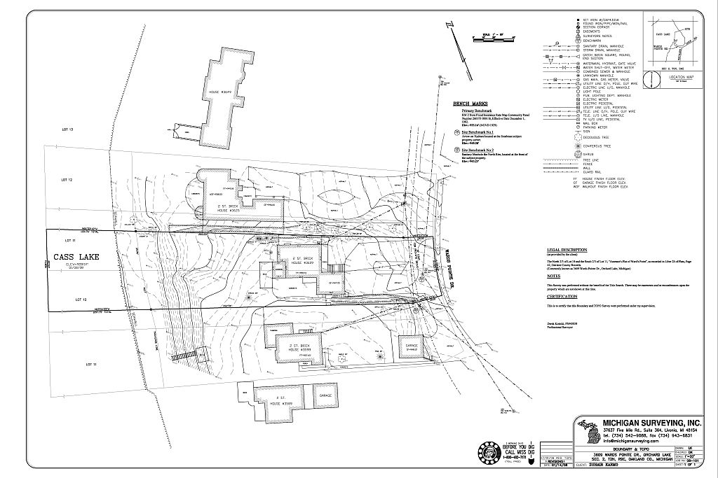
The TOPO Survey pictured above was performed for the redevelopment of a single family residential parcel.
The client’s intention was to demolish an existing house and build a new, larger, house with a walkout basement closer to the water’s edge. Extensive landscaping was also planned along with a boat launch.
ALTA/ACSM Land Title Survey
Also called: ALTA Survey, ALTA...
Title Insurance plays an important role in protecting lenders’ and purchasers’ land investment. To be able to evaluate the property and the risks associated with issuing a title insurance policy on the property, a title insurance company must, in part, rely upon an up-to-date and accurate Survey of the property.
The American Land Title Association (ALTA) and the American Congress on Surveying and Mapping (ACSM) have jointly developed the ALTA/ACSM Land Title Survey standards to use in preparation of these Surveys.
An ALTA Survey verifies a legal description and possible easements of subject property. Additional items like planimetric and topographic data, utilities and site improvements, zoning and hazard land information could be requested as outlined in Table A.
ALTA Surveys are almost exclusively performed for multi family residential, commercial or industrial properties.

The ALTA Survey pictured above was a part of a multi-site transaction of heavy industrial manufacturing facilities along with associated office/technical complexes.
A number of errors and ambiguities in the recorded Legal Description were discovered (see Surveyor’s Notes).
Two original parcels were then combined into one parcel and a concise Description of Survey was prepared. All issues relating to the interpretation of faulty Legal Descriptions and creation of Description of Survey were discussed with title company and attorney teams of seller and buyer parties.
No comments:
Post a Comment